What You Are Actually Looking At: The Geology
To understand the Drakensberg is to understand a very specific sequence of catastrophes. The story starts about 300 million years ago, when what is now southern Africa was part of the supercontinent Gondwana and the region was covered by an inland sea. That sea filled with sediment over tens of millions of years, layer after layer of sandstone and shale compressing under its own weight. Then the sea retreated. Then came desert. Then came something much more dramatic.
About 182 million years ago, as Gondwana began to tear itself apart into the continents we recognise today, the crust of southern Africa cracked open along enormous fissures. Basaltic lava poured out from these fissures for perhaps two million years, covering most of what is now KwaZulu-Natal, the Free State, and Lesotho under a layer of volcanic rock more than a kilometre thick. This was not a volcanic eruption in the Mount Vesuvius sense — no single explosion, no ash cloud, no one dramatic event. It was a slow, relentless outpouring that buried everything beneath a hardened black cap of flood basalt and killed off most of the life on the continent in the process. This event coincided with the great Triassic-Jurassic extinction, one of the five largest mass extinctions in Earth's history.
What you are looking at when you stand below the Drakensberg escarpment is the eroded remnant of that basalt cap. For 180 million years, rivers carved downward through it and rain stripped it back, centimetre by centimetre, retreating from the original coastline position inland to where it stands now. Beneath the black basalt, the older pale sandstone of the Clarens Formation is exposed in a creamy yellow band of cliff — soft, porous, easily carved by water and wind. This is the layer that forms the caves and overhangs of the Little Berg, the foothills zone below the main escarpment wall. Above the sandstone: the hard, dark basalt that resists erosion and forms the great flat-topped peaks and the sheer wall of the upper escarpment. Read the cliff face and you are reading 200 million years of geological time, displayed in stripes of gold and black.
The Drakensberg is still retreating. At roughly one centimetre per decade, water and frost are currently chiselling the escarpment wall back toward Lesotho. In perhaps another hundred million years, if anything is still here to observe it, the basalt cap will be gone entirely and the softer rock beneath will erode quickly to a flat plain. For now, the wall stands. It is not going anywhere you will notice in a lifetime.
The San: The People Who Were Here First, and the Art They Left
Before the Zulu kingdom, before the Dutch settlers, before any of the layers of history that most visitors bring as context to South Africa, the Drakensberg was home to the San — the hunter-gatherer people who inhabited southern Africa for tens of thousands of years and who are among the oldest continuous human cultures on the planet. They called the mountains home not as a geographical convenience but as a cosmological one: the sandstone cave walls of the Little Berg were, in their belief system, a membrane between this world and the spirit world, and painting on them was an act of penetrating that membrane.
There are approximately 40,000 individual rock paintings across 600 cave and overhang sites in the Drakensberg, concentrated in the foothills between Royal Natal in the north and Bushman's Neck in the south. This is the largest and most concentrated body of rock art anywhere in Africa. The paintings span thousands of years — some are perhaps 3,000 years old; the San were still painting in the Drakensberg into the late 19th century, long after European settlers had arrived. The most recent paintings sometimes show horses, wagons, and men with rifles: the San recording the arrival of the people who would eventually dispossess them entirely.
For most of the 20th century, the paintings were assumed to be straightforward depictions of daily life: hunting scenes, animal portraits, domestic activities. It was only in the 1970s that the South African archaeologist Professor David Lewis-Williams, working at the Game Pass Shelter in the Kamberg area, decoded what they actually represent, in what is now regarded as one of the most significant breakthroughs in the history of rock art research.
The key was the eland — the large antelope that appears in the paintings more than any other creature, depicted with extraordinary care and anatomical precision, often in dying postures, often accompanied by human figures who appear to be taking on the eland's physical characteristics: hooves where feet should be, hair standing erect, legs crossed in the same posture as the dying animal, blood trickling from the nose. Lewis-Williams identified these human-eland hybrids as therianthropes — figures combining human and animal attributes — and recognised them as shamans in trance.
The San trance dance was (and remains, among San communities in the Kalahari) their central religious ritual. Women sat and clapped; men danced in a circle for hours, sometimes days, without food or sleep, until certain individuals entered an altered state of consciousness that the San understood as dying — leaving this world and entering the spirit world. In this state, shamans experienced physical symptoms remarkably similar to those of a dying eland: trembling, sweating, bleeding from the nose, the sensation of the body elongating, of merging with animals, of flying. When they returned from trance, they painted what they had seen and felt. The rock face was not a canvas; it was a portal, and the act of painting was an act of pressing through it into the other side.
The eland mattered above all other animals because the San believed it held the most supernatural potency of any creature — a concentrated power that, when released at the eland's death, could be harnessed by a shaman to heal the sick, make rain, mediate disputes, and enter the spirit world. The paintings are not art in the Western aesthetic sense. They are simultaneously medical records, religious ritual, spiritual technology, and cosmological map. Standing in a cave looking at a 2,000-year-old painting of a shaman with eland hooves, nose bleeding, reaching into the rock face, you are looking at an extraordinarily sophisticated system of belief expressed in pigment mixed from iron oxides, charcoal, animal blood, and plant matter and applied with brushes of animal hair. It is, by any measure, one of the great cultural achievements of the human species on this continent.
The three main publicly accessible rock art sites are the Main Caves at Giant's Castle Game Reserve (guided tours; well-presented interpretive centre), Battle Cave at Injasuti (a dramatic 4-hour guided walk to a shelter with 750 individual paintings, including a battle scene between San and Nguni people), and the Game Pass Shelter at Kamberg (the site of Lewis-Williams' "Rosetta Stone" panel — the most important single panel of rock art in southern Africa, guided tours from the Kamberg Rock Art Centre). A custodian guide must accompany all visits. You cannot enter rock art sites alone and you should not try to. The paintings are irreplaceable and extremely fragile: touching them, even breathing close to them repeatedly, causes damage. Do not touch. Do not photograph with flash. Do not camp in a rock art shelter.
What Happened to the San
The San were systematically dispossessed and killed. This is the short version, and the honest one. From the 18th century, European settlers expanding northward from the Cape, and Nguni-speaking agricultural communities expanding southward and westward under the pressures of the Mfecane (the upheaval of Zulu kingdom expansion in the early 19th century), simultaneously enclosed the San's land, hunted out the game they depended on, and — in the case of the settlers — conducted organised killing campaigns against San communities who raided livestock in desperation. The last San communities in the Drakensberg were effectively eliminated by the late 19th century. The paintings they left behind are the primary record of their existence in these mountains.
The San who survive today — about 100,000 people, mostly in Botswana, Namibia, and South Africa — are genetically and culturally the descendants of the oldest continuous human population line on earth, confirmed by mitochondrial DNA studies as the basal branch from which all other human populations diverged. They were here long before anyone else. The Drakensberg rock art is their legacy, and it is worth more attention than most visitors give it.
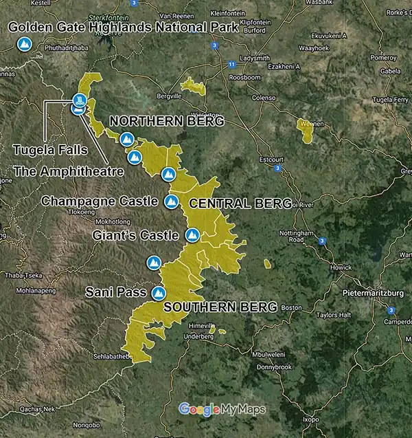
Navigating the Berg: Three Zones
The section of the Drakensberg relevant to most backpackers runs for about 180 kilometres along the KwaZulu-Natal border with Lesotho, divided into three broad zones. Each has a distinct character and set of access points. Understanding the difference will save you a wasted journey.
The Northern Drakensberg: The Amphitheatre
This is where most first-timers go, and with good reason — the Northern Berg contains the single most dramatic piece of mountain scenery in South Africa. The Amphitheatre is a five-kilometre-wide, 1,200-metre-high curved basalt wall in the Royal Natal National Park, a geological formation so improbable it looks like a film set. The Tugela River pours off the top of it in a cascade of five distinct drops totalling 948 metres — making it either the second tallest or possibly the tallest waterfall in the world (measurements of both Tugela and Venezuela's Angel Falls are genuinely disputed, the margin between them smaller than the measurement uncertainties). In winter it freezes. In summer it flows with enough force to be heard from the valley floor.
The main access hub for the Northern Berg is the Bergville/Winterton area, about four hours' drive from Johannesburg and two and a half from Durban. Backpacker accommodation concentrates around here, with the best hostels offering guided hikes to the Amphitheatre via the Sentinel Peak chain ladder route — a full-day hike that takes you to the summit of the escarpment and to the top of Tugela Falls. This is the hike that people come back from unable to describe adequately to anyone who hasn't done it.
The Central Drakensberg: Peaks and Rock Art
The Central Berg is larger, wilder, and less crowded than the North. It encompasses the Cathedral Peak area, Champagne Valley, Monk's Cowl, Injasuti, and Giant's Castle — a landscape of high peaks exceeding 3,000 metres, deep gorges, excellent rock art sites, and the most extensive network of multi-day hiking trails in the mountains. Cathedral Peak itself (3,004 metres) is the most accessible of the major summits — a full-day climb requiring no technical equipment, just fitness and an early start. Giant's Castle (3,315 metres) is a harder proposition.
Champagne Valley is the commercial hub of the Central Berg, with plenty of mid-range and budget accommodation. Cathedral Peak is quieter and more atmospheric — accessed by a single road into its own valley, with limited accommodation options and that quality of remoteness that makes the Drakensberg feel genuinely wild rather than managed. For multi-day hiking, Injasuti is the preferred base for serious hikers: a camp with cave overnight routes into the high Berg and access to Battle Cave, one of the best rock art sites in the mountains.
The Southern Drakensberg: Sani Pass and Lesotho
The Southern Berg is defined by one thing above all others: the Sani Pass. This is the only road crossing of the Drakensberg escarpment in KwaZulu-Natal, connecting the South African lowlands to the Kingdom of Lesotho at an altitude of 2,876 metres. It is a gravel track of nine kilometres that climbs 1,332 vertical metres in gradients of up to one-in-three, through a series of hairpin bends with names like Devil's Corner and Suicide Bend, over ground that ranges from bone-dry loose gravel in good conditions to a river of boulders and ruts after rain. The full details are in the Things To Do section below. The base camp for the Sani Pass is the Underberg/Himeville area, about two and a half hours from Durban.
Drakensberg FAQs For Backpackers
When is the best time to go?
The Drakensberg has two distinct seasons and they are genuinely different experiences. Choosing the wrong one for what you want to do will significantly affect your trip.
Summer (November–March): Green, dramatic, dangerous. The mountains are at their most spectacular visually — the foothills are intensely green, the rivers run full, and the waterfalls are at their most powerful. But summer in the Drakensberg is also electrical storm season. Violent thunderstorms build over the escarpment every afternoon with clockwork regularity, typically from around 2:00 PM onwards. Lightning is not a minor risk here. The Drakensberg sits in the region of South Africa with the highest concentration of air-to-ground lightning strikes in the country — which has one of the highest lightning mortality rates in the world. Hikers have died on these mountains from lightning strikes. The rule is absolute: be below the ridgeline and under cover before 2:00 PM in summer. This means 5:00 AM starts for any serious day hike. It also means the multi-day escarpment hikes are significantly more committing in summer — you are on exposed high ground for multiple consecutive days, and the weather is unpredictable.
Winter (April–September): Cold, dry, clear. The electrical storms stop almost entirely. The skies are a blue that doesn't exist in summer. Visibility on the escarpment can extend for 200 kilometres. Snow settles on the high peaks and sometimes on the passes — the Amphitheatre under snow is extraordinary. The days are cold but manageable with proper clothing; nights on the escarpment can drop well below zero even in June and July. Rivers are lower, meaning stream crossings are safer. The rock art caves are at their best in dry conditions. This is the preferred season for multi-day hiking, the Sani Pass drive, and anyone who wants reliable weather.
The sweet spot: April–May and August–September. End of the wet season or end of the dry season — the mountains are still green from summer rain in April/May, the storms have eased, and the days are warm enough to be comfortable in a base layer. September brings wildflowers across the foothills. These shoulder months are when the Drakensberg is at its most balanced.
Do I need a car?
Yes, with one qualification. The Drakensberg is not served by any meaningful public transport, and the access roads into the different valleys — Northern, Central, and Southern — are not connected to each other along the escarpment. You drive in from the lowlands on a road that goes into a valley, and that valley is your base. Getting between the Northern and Central Drakensberg areas requires driving back out to the main N3 highway and re-entering via a different road, which adds 60–90 minutes. A car is not optional if you want to explore more than one zone.
The qualification: many hostels in the Bergville area (Northern Berg) offer shuttle pickups from the N3 and run their own guided hiking day trips, which means that a backpacker based at a single hostel without a car can experience the Amphitheatre hike and several other Northern Berg activities without needing to drive. If your sole destination is the Amphitheatre or the Sani Pass (where tour operators run day trips from Underberg), you can survive without a car by planning ahead and booking through your hostel. For everything else — Central Berg, Cathedral Peak, the rock art sites at Giant's Castle, any self-directed hiking — you need your own vehicle.
Most access roads are tarred to the park gates. Some valley roads beyond the gates are gravel but manageable in a standard sedan in dry conditions. The Sani Pass road is the one exception: the nine-kilometre section between the South African and Lesotho border posts is 4x4 only, mandatory and enforced. Details below.
What does it cost?
The Drakensberg is genuinely affordable. Dorm beds at backpacker hostels run from €10–€18 per night. Ezemvelo KZN Wildlife park entry fees are approximately €4–€7 per person per day, payable at the gates. Day hikes within the park are generally included in the entry fee. Guided hikes run through hostels — including the Amphitheatre chain ladder hike — typically cost €20–€40 per person inclusive of transport. Rock art guided tours at the major sites cost approximately €5–€10. The Sani Pass tour operators charge approximately €35–€50 per person for a guided day trip including transport. A daily budget of €35–€60 covers accommodation, food, park entry, and one paid activity. If you are camping rather than hostelling, drop that to €20–€40.
What should I actually pack?
This question matters more in the Drakensberg than in most places on the South Africa backpacker circuit, because the consequences of being underprepared here are not discomfort but genuine danger. The mountains change fast. A clear morning can become a violent electrical storm by early afternoon. A warm lowland day at the base of the escarpment can become sub-zero wind chill on the plateau within three hours of hiking. The following are non-negotiable regardless of season:
Waterproof jacket and trousers. Not water-resistant — waterproof. The storms here are serious. A €20 pacamac from a supermarket in Pietermaritzburg will fail on a Drakensberg escarpment in a July afternoon hailstorm. Bring something rated for genuine mountain weather.
Warm layers. Even in December, the plateau temperature at 3,000 metres can drop dramatically when cloud comes in. A fleece and a windproof layer are essential on any summit day. In winter, pack for below-zero overnight temperatures if you are doing any multi-day hiking with cave or tent camping.
Navigation tools. The Drakensberg has trails marked by cairns — small stacks of stones built by previous hikers. Some are accurate. Some lead nowhere. Some have been built by people who were also lost. In mist, which can descend in minutes on the escarpment, cairns become useless. Download the relevant Slingshot or Avenza hiking maps to your phone before you leave and keep your phone charged. Carry a paper backup. Tell the park office and your hostel your planned route and expected return time. If you don't come back, someone needs to know where to start looking.
Water and purification. Mountain streams in the Drakensberg are generally clean, particularly at altitude. A filter or iodine tablets allow you to refill from the rivers rather than carrying weight. In summer, the rivers run well. In winter, some streams on the plateau are reduced to trickles — carry more than you think you need.
Can I hike independently or do I need a guide?
Most day hikes within the park boundaries can be done independently with a map and the precautions described above. The Tugela Gorge walk to the base of Tugela Falls, the walks around Royal Natal's valleys, and most of the lower Cathedral Peak trails are well-used enough that you will encounter other hikers regularly. Sign the register at the park office before every hike — this is not optional, it is the system that triggers search and rescue if you don't return.
The Amphitheatre chain ladder hike (to the summit of the escarpment via Sentinel Peak) is technically independent-accessible but is significantly better done with a guide for your first time — the plateau navigation after the ladders requires map confidence, especially in summer when cloud can come in. Most hostels in the Northern Berg run this as a guided group trip, which solves the navigation problem and adds the social dimension of doing something serious alongside other people who are also having the experience of their lives.
Rock art sites: guides mandatory, as described above. Sani Pass on foot or with your own 4x4: no guide required, but read the logistics carefully below. Multi-day escarpment traverses and cave routes: experienced hikers can do these independently with the right preparation; beginners should hire a guide through Ezemvelo KZN Wildlife or one of the established local operators.
Safety In The Drakensberg
The Drakensberg is not dangerous in the way that some of South Africa's urban environments are dangerous. The risks here are natural, and they are manageable with preparation and respect. But they are real, and several of them are lethal.
Lightning: The Primary Killer
Lightning is the most serious hazard in the Drakensberg, and it is not close. The area receives the highest frequency of air-to-ground lightning strikes in the entire world. In summer, afternoon thunderstorms are a near-daily occurrence, and on exposed ridgelines and the upper escarpment, there is nowhere to shelter from them. Hikers have died here from lightning strikes. The safety protocol is simple and absolute: in summer, plan to be below the ridgeline and in shelter by 2:00 PM. This means early starts — 5:00 AM for serious summit hikes. Watch the western sky from mid-morning. If you see cloud building over the escarpment, do not ignore it and assume it will pass. Turn around.
If you are caught in a storm on exposed ground, the correct position is not lying flat (ground current from a nearby strike runs through your entire body), not sheltering under a tree (side-flash), and not huddling in a group (one strike can kill multiple people). The correct position is the lightning crouch: squat low, feet together, knees together, hands over ears. If your hair stands on end or you feel a tingling in your skin, you are in the charge shadow of an imminent strike — get into this position immediately. Spread out from the rest of your group so that one strike does not kill everyone. Spread out far enough that survivors can assist casualties. Caves are complicated: they can offer protection, but a cave at the base of a cliff during a strike on the cliff above can conduct lethal ground current. The Drakensberg hut system offers proper shelter; use it if you are multi-day hiking.
Flash Floods And River Crossings
After heavy summer rain, rivers in the Drakensberg can rise with terrifying speed — a gentle ankle-deep crossing in the morning can become an impassable torrent within an hour if there has been heavy rain on the plateau above, even if it is dry where you are standing. Never attempt to cross a flooded river. Wait. The water usually drops as fast as it rose. If it doesn't, make camp and wait again. Several hikers have drowned in the Drakensberg attempting crossings that seemed manageable. The Berg rivers, particularly in the central and northern zones, are bordered by narrow gorges in places where there is no alternative to crossing. Know your route, know the crossing points, and know what to do if they are impassable before you leave.
Hypothermia And Exposure
The Drakensberg plateau at 3,000 metres is a cold environment, and it can become a lethally cold one very quickly when wind and rain arrive simultaneously. Hypothermia — the dangerous lowering of core body temperature — does not require sub-zero temperatures. Wet, wind, and moderate cold (5–10°C) are sufficient to kill an underprepared person over several hours. Signs of serious hypothermia include slurred speech, confusion, lack of coordination, and paradoxical undressing (the person removes clothing because they mistakenly feel warm). If a member of your party shows these signs, this is a medical emergency. Get them dry and insulated immediately and activate the park's emergency response.
The escarpment caves marked on Drakensberg hiking maps serve as emergency shelters. They are not luxurious — most are shallow overhangs with a dirt floor — but they will protect you from wind and rain. Do not rely on them as your planned sleeping spot; always carry a tent on multi-day hikes. Never camp in a painted rock art shelter.
Snakes
There are over 25 species of snake in the Drakensberg region, of which four are dangerous: the Puff Adder, the Berg Adder, the Night Adder, and the Rinkhals (a spitting cobra). The Puff Adder is the most dangerous — slow-moving, well-camouflaged, and responsible for more snakebite fatalities in Africa than any other species. It favours rocky ground in exactly the terrain you will be hiking. The precautions are standard: wear proper hiking boots (not trail runners), watch where you put your feet and hands, do not sit down on rocks without checking first. In practice, snake encounters on Drakensberg trails are uncommon; most hikers never see one. But two or three hikers are bitten each year in the region, almost always by Puff Adders, and almost always because of inattention.
Getting Lost
People get lost in the Drakensberg. The plateau in mist, which can descend in minutes, looks the same in every direction. Cairns are unreliable. Paths across the basalt are often invisible. Always carry a downloaded offline map on your phone, carry a paper backup, sign the register at the park office, and leave your planned route with your hostel. If you become disoriented, stay calm, stay where you are, and use your whistle — six blasts in succession is the universal distress signal in these mountains. The park's emergency rescue service is efficient but the mountains are big and rescue by helicopter is expensive (€800–€1,500). Your travel insurance must cover mountain rescue and helicopter evacuation. If it doesn't, get different travel insurance before you go.